Mada za sehemu hiiMap Reading And InterpretationMada 4
- Concept of Map Reading
- Reading and Interpreting Topographical Maps
- Methods of Showing Relief on Topographical Map
- Cross Section
- Types of maps that describe the physical (natural) and man-made (artificial or cultural) features of a given area.
- Physical features include relief, vegetation, and drainage, among others.
- The plan or layout of the river with its tributaries until it reaches its destination, such as a lake, main river, swamps, or the ocean.
- The concept of drainage includes rivers, swamps, lakes, waterfalls, and flood areas.
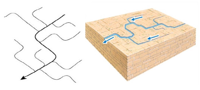
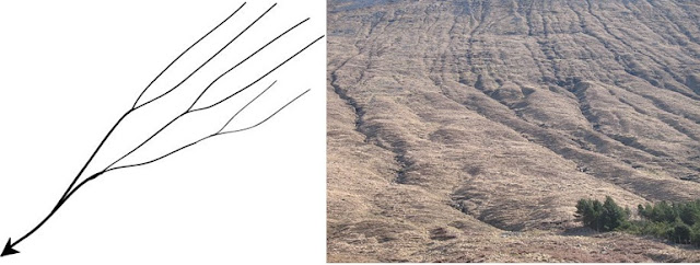
The plan or layout of the river with its tributaries, or the network displayed by a river and its tributaries.
- A pattern in which its tributaries convey (join) to the main river at an acute angle, resembling the shape of a tree trunk and its branches.
- Dendritic patterns are common in areas of gentle slope and of uniform (homogeneous) rock hardness.

- The pattern in which its tributaries convey or join the main river at almost a right angle.
- This type is commonly found in areas with severe cracks or fractures, mostly in rocks with alternating hard and soft rock layers.

- The pattern or layout in which its tributaries flow outward from the center (summit) or the peaks of mountains.
- Its pattern resembles a spoked ring of a bicycle wheel, where streams flow out in every direction from the center.

- The pattern in which almost all streams flow from all directions, converging towards the center, which can be a swamp, lake, or depression.

- A pattern that resembles the trellised pattern, but with tributaries joining the main river at a right angle.
- This pattern is common in areas that are faulted.
- A pattern with a series of streams flowing on the flanks or around the dissected dome, depression, or crater.
- This pattern occurs where there is an alternate band of soft and hard rocks.

- Consists of a series of streams running parallel to one another.
- In some cases, streams may flow into one big river.
- The surface rock on topographical maps is not directly indicated.
- Some clues are needed to identify the rock type and structure of the mapped area.
Indicators Used to Show the Type of Rock Present in a Certain Area
Land Forms
Landforms shown on the topographical maps help on interpretation of rock type for example:
- The presence of volcanic landform such; crater, caldera, name of the volcanic mountains suggest the presence of igneous rock.
- The presence of erosion and depositional features such as depression, sand dunes, coral reef suggest the presence of sedimentary rock. Flood plain suggests sedimentary rock.
- The presence of highland with steep slope indicated that rock are hard and resistance rock that may indicate presence of metamorphic rock.
- Thick forest suggests the presence of igneous rock.
- Poor vegetation cover suggests the presence of sedimentary rocks or metamorphic rock.
- Nature of the rock. Absence of streams indicates that the rocks are permeable. Thus this depict that the rock is soft which can be either sedimentary, limestone or sandstone.
- Presence of many streams on surface, indicate that the rock are impermeable such as igneous or granitic rock.
-
Read the contour and the conventional symbols or signs on the map to identify types of relief.
-
Relief can either be highland relief with lower parts or lowland relief.
-
Describe the relief with associated landforms.
-
When determining the type of relief, first look at the units on the vertical interval (V.I), whether the unit is in meters or feet.
-
If the units are in feet, take the highest value and convert it into meters.
- (1m = 3.3ft)
-
Finally, determine the type of relief.

Climate is the average weather condition experience in a given area over a long period not less than 30 years. Topographical maps may be used to identify the climate of given mapped area. Some hints used in interpreting climate from topographic map Latitude of the area.
- Distance from equator used to determine kind of climate of a certain area. For example the area with latitude 5 degrees north or south of equator the area is considered to be in equatorial climatic condition while the area between 5 to 15 N/S is in tropical climatic condition, 15-30 N/S of the equator imply Semidesert 30-40 N/S implies desert climate or Mediterranean climate.
- Water bodies. a general high density of streams indicates that the area receives high rainfall, presence of low density or seasonal streams, salt lakes and boreholes indicate aridity.
- Vegetation, presence of forest in the map indicates heavy rainfall while woodland vegetation indicates moderate rainfall. shrubs, thickets and grassland indicate dry condition or light rainfall Crops, crops grow in those areas where water and temperature conditions are favorable for their growth.
Topographical map may contain information on economic activities undertaking usually the following are shown on topo maps.
- Agriculture: look on the presence of Rural settlement in absence of other activities scattered cultivation storage houses/center plantation or estate (indicate large-scale agriculture) industry such as Ginners, Hulleries and Decorticator.
- Pastoralism: look on the presence of cattle market-cattle dips veterinary installation (Vet. Office)/center Creamers (lace where milk, cream butter and cheese are processed scattered vegetation or dominated by scrub/shrubs) Bore holes.
- Mining: look on the presence of; symbols of PIC () and shovel (salt work quarrying Roasting Sign Tin-TN, Iron-Fe.
- Fishing: look on the presence of; water bodies such as lakes, seasonal swamps, rivers, dams, and ocean.
- Trade and Transportation: look on the presence of Road, railway, towns and market
- Lumbering; look on the presence of; forest with track-roads ending on their edges. Sawmill Sao hill forest -Note: thicket, scrubs/shrubs and bamboo trees cannot be exploited as a timber.
- Tourism: look on the presence of; National parks, Game reserve Recreational center's e.g. museum, archives beaches etc Landscape e.g. crater depression etc.
A settlement is a place where people live. It may be as small as single house in a remote area or as large as a mega city.
Types of Settlement
- Urban Settlement; Is commonly found in areas of District administrative centers, Regional administrative centers, and Capital city of a country.
- Rural Settlement; Is an area where the majority of people approximately to cover 80% engage in agriculture
It is a layout of dwellings in a particular place. The signs showing settlements on topographical maps are observed to have varied arrangement.
The most common pattern include the following:
- Also called scattered settlement pattern.
- The houses are widely spaced from one another.
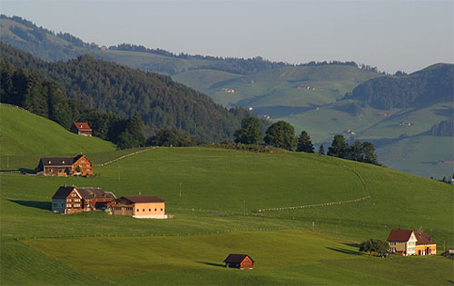
- Houses and other related forms are compacted together.

- Houses are concentrated along an elongated object of economic significance, such as a road, river, railway lines, and others.
- A reliable source of water supply e.g. presence of permanent rivers, lakes.
- Gentle slope i.e. people prefer to establish settlement in less hazardous areas
- Good soil for agriculture
- Pleasant climate condition
- Transport and communication.
A place can be located by its name where it is found. A more accurate way of locating a place is the use of latitudes and longitudes, this method is used by scalars at sea and aircraft in their flights. Generally, position of any place can be located by using:
- Place names
- Bearing
- Latitudes and longitudes
- Grid reference
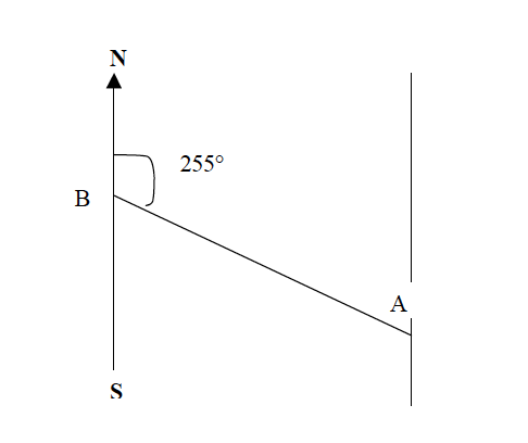
The bearing of a place on a map can be found when the north is given. The north is usually indicated by an arrow pointing to the north.
Example 1: Find the bearing of point B from point A
Procedures
- Join points B and A with a straight line.
- At point A, draw a line parallel to the north-south line.
- Using a protractor, measure the angle from point B towards the north along the line BA.
Mwalimu
Unasoma somo hili? Niulize nikuelezee chochote kilichomo.
Ingia ili kumuuliza Mwalimu wa AI wa Sonza kuhusu mada hii.
Ingia ili kuuliza