Mada za sehemu hiiPhotograph Reading And InterpretationMada 4
- Types of Photographs
- Reading and Interpreting Photographs
- Identifying and Interpreting Physical Features
- Identifying and Interpreting Human Activities
Human activities on a photograph are depicted by various forms of land use. The uses of land may be in the form of agriculture (crop cultivation and animal husbandry), forestry, settlement, wildlife conservation, mining and construction of infrastructures, among other uses.
This includes crop cultivation and livestock rearing. It is practiced at subsistence and commercial levels. It is easy to identify agricultural activities on ground photographs. To be able to identify these features on vertical aerial photographs, it requires close examination of the features.
Type of farming evidences
Subsistence crop farming
- Some houses are permanent while others are temporary
- The land is often divided into small plots owned and cultivated by individual farmers
- Mixed farming is practiced
- Simple farming tools such as hoes, mattocks, pangas and rakes are used
- Fields are separated by hedges
Subsistence livestock farming
- Indigenous and exotic animal breeds are kept
- Animals are grazed on grassland or semi-arid vegetation
- Large herds of local cattle (zebu), goats and sheep
Commercial livestock farming
- Large fields divided into paddocks
- Presence of cattle sheds near farm houses
- Windmills for water supply
- Presence of water tanks, ponds or reservoirs in the dry areas
- Evidence of livestock infrastructures such as cattle dips or spray races, abattoir, cattle bomas, slaughter slab, etc.
- High grade exotic or crossed cows with large udders
- Milking parlour with milking machines, and milk processing plants
- Indoor grazing units
Commercial crop farming
- Presence of cash crops on an extensive area
- Evidence of modern farming methods, e.g. farm machinery
- Facilities for collecting crops, e.g. sheds and stores
- Presence of access or feeder roads within the farm
Plantation farming
A single crop covering extensive stretches of land, e.g. sugarcane, tea, coffee, sisal, wheat
- Presence of storage facilities, e.g. silos
- Many laborers in the fields
- Nucleated settlement within the farm. These are usually for the workers' housing
- Presence of a network of roads crossing the farm to facilitate mechanization and haulage of inputs and produce to and from the farm, respectively
The following evidence can be used as a guide in identifying industrial and mining activities on a photograph:
- Presence of factory buildings with tall chimneys that might be issuing a lot of smoke
- Nucleated settlements in the neighborhood, likely to be the laborers' houses
- Tall chimneys emitting flames and a network of pipes with large tanks in the distance could indicate an oil refinery
- Large open pits, large excavators and lorries carrying loads of rocks could indicate open cast mining
- A large area with derricks (oil rigs) could point to an oilfield where oil is mined
Lumbering activities could be indicated by the presence of the following features/activities:
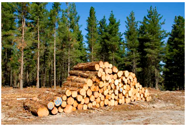
- Logs floating down the river
- People cutting trees using manual or power saws
- Large forest clearings with tree stumps and piles of logs
- People loading timber onto lorries or tractor trailers
- Logs piled near a saw mill
Transport
The clues or indicators for transport include:
- Presence of motor vehicles and roads
- Animals carrying loads on their backs
- Presence of railway line
- Presence of ports, boats, ships or large water bodies
Communication
This may be indicated by the presence of telephone lines, telephone booths, satellite dishes, buildings with masts and wires connecting the masts, post office, radio or television station, newspapers or newspaper stands, etc.
Look for the presence of: national parks, game reserve, recreational centres e.g. museum, archives, beaches, etc., landscape e.g. crater depression, etc.
Look for the presence of water bodies such as lakes, seasonal swamps, rivers, dams, and ocean. These should be surrounded by settlement.
A settlement comprises of a group of buildings in an area where people live and carry out social and economic activities. There are two types of settlements: rural and urban settlement.
Rural settlements
The following features can indicate this:
- Many semi-permanent and a few permanent buildings such as grass-thatched houses or iron roofed houses with mud or brick walls
- Evidence of farming, fishing activities etc.
- Unplanned or unevenly distributed settlement which is associated with plantations etc.
Urban settlements
The following features can identify this:
- Permanent buildings, which dominate the area
- Regular street patterns
- Many large buildings and warehouses indicating an industrial area
- High numbers of people or population
- Availability of many motor vehicles on the road, which may lead to traffic jams
It is a layout of dwellings in a particular place. The signs showing settlements on topographical maps are observed to have varied arrangement.
The most common patterns include the following:
- Dispersed settlement pattern: It is alternatively called scattered settlement pattern. The houses are widely spaced from one another.
- Nucleated settlement pattern: Houses and other related forms are compacted together.
- Linear settlement pattern: Houses are concentrated along an elongated object of economic significance like a road, river, railway lines and others.
- A reliable source of water supply e.g. presence of permanent rivers, lakes.
- Gentle slope i.e. people prefer to establish settlement in less hazardous areas.
- Good soil for agriculture.
- Pleasant climate condition.
- Transport and communication.
Mwalimu
Unasoma somo hili? Niulize nikuelezee chochote kilichomo.
Ingia ili kumuuliza Mwalimu wa AI wa Sonza kuhusu mada hii.
Ingia ili kuuliza