Mada za sehemu hiiUses Of MapsMada 3
- The Concept of Latitudes and Longitudes
- Uses of Latitudes and Longitudes
- Calculation of time at places on the map using longitudes
The Concept of Latitudes and Longitudes
In order to understand and use maps effectively, various lines are utilized to represent geographical information. Latitudes and longitudes are two important types of lines that help in locating places on a map.
Latitudes and Longitudes
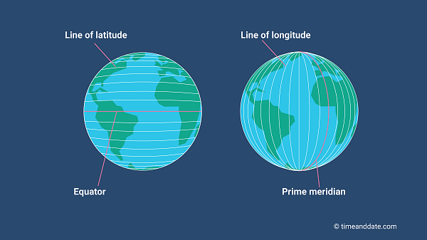
- The Earth is spherical in shape and is divided by imaginary lines known as latitudes and longitudes.

Latitudes
- Latitudes are horizontal lines that run across the Earth.
- They are parallel to the Equator, which divides the Earth into two equal parts: the Northern Hemisphere and the Southern Hemisphere.
- Latitudes are measured in degrees, with the Equator being 0° latitude. The latitudes range from 0° at the Equator to 90° at the poles.
Longitudes
- Longitudes are vertical lines that run from the North Pole to the South Pole.
- The Prime Meridian is the main longitude, marked as 0°, and divides the Earth into two equal parts: the Eastern Hemisphere and the Western Hemisphere.
- Longitudes are also measured in degrees, with 180° longitude marking the farthest point east or west of the Prime Meridian.

Measuring Degrees
- Both latitudes and longitudes are measured in degrees (°). For example, a location might be described as being 30° North latitude and 60° East longitude.
Latitude
Latitudes are imaginary parallel lines drawn on the Earth's surface, running North and South of the Equator. The Equator is the latitude with zero degrees (0°) and divides the Earth into two equal hemispheres: the Northern Hemisphere and the Southern Hemisphere.
Key Characteristics of Latitudes
- Latitudes are drawn parallel to the Equator, which means they do not intersect.
- The degree of a latitude is counted from the Equator and is identified depending on the hemisphere (North or South).
- As you move away from the Equator, the degrees of latitudes increase towards the North or South poles.
Important Latitudes
- Tropic of Cancer: Located 23½° North of the Equator.
- Arctic Circle: Located 66½° North of the Equator.
- Tropic of Capricorn: Located 23½° South of the Equator.
- Antarctic Circle: Located 66½° South of the Equator.
These important latitudes form circles whose degree values increase as you move away from the Equator towards the North and South.
Special Note
- The Equator is the only latitude that forms a great circle, meaning it divides the Earth into two equal halves.
Practical Use of Latitude
The line of Equator plays a key role in locating short routes for water and air transport, helping to determine the most efficient paths.

Longitudes
Longitudes are imaginary vertical lines drawn on the Earth's surface, extending from the North Pole to the South Pole. These lines help in measuring distances east and west on the Earth's surface.
Key Characteristics of Longitudes
- The Prime Meridian (also called the Greenwich Meridian) is the longitude at zero degrees (0°), drawn through the middle of the Earth as shown in Figure 3.
- Longitudes are drawn East and West of the Prime Meridian.
- The Earth has a total of 360 degrees of longitude.
- From the Prime Meridian, other longitudes are drawn every 15 degrees towards the East and West.
- The longitudes reach up to 180 degrees on both sides of the Prime Meridian.
Key Point
- Every longitude line forms a great circle, just like latitudes.
Differences Between Latitudes and Longitudes
A comparison of the differences between latitudes and longitudes is presented in Table 1. Differences between latitudes and longitudes.
| Latitudes | Longitudes |
|---|---|
| Latitude with zero degree (0°) is known as the Equator. | Longitude with zero degree (0°) is known as the Prime Meridian. |
| Equator is the only latitude that makes a great circle which divides the Earth into two equal parts: Northern and Southern Hemispheres. | Every longitude makes a great circle that divides the Earth into two major parts. |
| Latitudes are lines drawn parallel to the Equator. | Longitudes are vertical lines and they all meet at the North and South Poles. |
| Latitudes are measured from zero degree at the Equator (0°) up to 90 degrees (90°) towards the Southern or Northern Hemisphere. | Longitudes are measured from zero degree, at the Prime Meridian (0°), up to 180° towards the East or West. |
| Latitudes help to show the distribution of regions with different climatic characteristics. | Longitudes are used to show the differences in time between one part of the Earth relative to another. |
Swali
Ingia ili kuwasilisha jibu lako na lihesabiwe katika umahiri wako.
Ingia ili kufanya mazoeziMwalimu
Umekwama? Niulize chochote kuhusu mada hii.
Ingia ili kumuuliza Mwalimu wa AI wa Sonza kuhusu swali hili.
Ingia ili kuulizaMajadiliano
Hakuna maswali bado